Tag: Baker City Oregon

Not Every Day is Dreamy Living in an RV

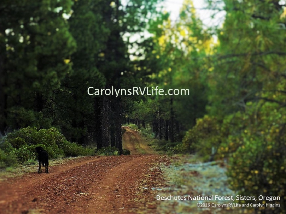
After boondocking for six weeks in the National Forests near Medford, Klamath Falls and Sisters Oregon, I decided it was time to move on.  I left a perfectly good camp in Deschutes National Forest to drive 275 miles to a new location near the tiny town of Richland in northeastern Oregon.  My inner Nomad was alive and kicking! Why stay in one spot when there’s a whole country to explore? The dent in my budget from the catalytic converter, a new cabin battery and the trip to Arizona has been recouped and now I have enough in reserve to afford to travel again .

I’d been happy there; nestled among new growth Lodgepole Pines, Mountain Hemlocks and Subalpine Fir. It was far away from people and noise, yet just 5 miles from the tiny tourist town of Sisters and 28 miles from the bigger city of Bend. However, the scenery was getting passé and the surrounding roads and trails had all been walked.  I was ready for a change of scenery: the open road beckoned.

Deschutes National Forest Boondocking
Deschutes National Forest Near Sisters

When I declared it was time to move on, my traveling buddy Bob and I carefully studied the Delorme and Benchmark Atlases, consulted the Public Lands Android app, Google Earthed various National Forest and BLM roads and referred to the Verizon coverage map to carefully select a camp that would give us everything we needed to live and work.   We finally found a spot that seemed perfect:  30 miles east of Baker City, near the tiny town of Richland. It looked far enough away to get the solitude we both enjoy, resting on the edge of the Powder River in the high desert – and according to the Verizon coverage map, a strong 4G signal. We’d found our next home!

On Wednesday morning, I headed east, excited to be getting further from my former home state of California, exploring new places and being on my own (even if just for a few days until Bob and our camp guest Cathleen met up with me again).  Within a few hours I was at the turnoff  to John Day Fossil Beds National Monument and the Painted Hills.  I’d been hoping to find a place on the surrounding BLM land to camp for the night but I’d been in a cell phone dead zone since the small town of Prineville about 100 miles back. I had a project due for work; I needed a cell signal and had relied on the Verizon Map. There was supposed to be cell service along Route 26!

I drove the seven miles out to the Painted Hills site without so much as a peep out of my phone alerting me that my notifications had come to life. It was getting on in the day and I was ready to stop driving. The frustration and worry settled in like a heavy mass in my gut.  I didn’t want to have to turn all the back to Prineville but I had to get some work done! Damn the lying Verizon Map!

Painted Hills Near Mitchell, Oregon
Painted Hills near Mitchell, Oregon

Well, I’m here, I may as well enjoy the scenery! I leashed up Capone and walked the short trail to the lookout for the best views of the red streaked hills. The sign near the parking lot explained that the layers of yellow, red and gray painted onto the sandy hills represent different geological eras. The different layers were formed when the area was an ancient river floodplain. The black soil is lignite, a vegetative matter that grew along the floodplain. The grey coloring is mudstonesiltstone, and shale. The red coloring is laterite soil that formed by floodplain deposits when the area was warm and humid. (Source: Wikipedia). I spent about an hour taking pictures, wandering around and enjoying the quiet remoteness before heading back on Route 26 in search of a cell signal and a place to spend the night.

I drove another 74 miles and ended up at Clyde Holliday State Recreation Site in Mt. Vernon, Oregon.  They have first-come-first serve tent and RV sites with full hook-ups (and a few Tee-pees that have to be reserved ahead of time), a good 4G signal – and hot showers! Sold!  It was about 5:00 pm on a Wednesday and there were only three sites available, which were filled by dark.

As I rolled in, I immediately noticed how clean and well landscaped it was, with willowy Cottonwood trees, plush green grass and enough shrubbery and trees that each site had some privacy. It rested between the gentle John Day River and Highway 26 (a surprisingly busy and loud highway).  For $24 I got to plug in and recharge my cabin battery, refill my fresh water, dump my tanks AND take a nice long hot shower in a roomy, clean stall with plenty of hot water. Well worth the investment!

Once I was set up, Capone and I went for a leisurely walk along the river as the sun set.  It had only been about five hours since I left camp in Sisters, but it already felt like I’d been on the road a long time.

Wallowa NF outside Baker City, Oregon

The next day I left the campground around 11:00 am and traveled through lush green forests, along narrow roads hugging canyons sliced by the meandering Powder River and middle-of-no-where farmland, as I headed east on Route 26 toward Richland. I stopped along the way in John Day, parked Big Bertha just off the tiny main drag and lazily wandered the street of the quaint old-time town.   I even had a surprisingly delicious almond milk cappuccino at the John Day Corner Cup Café (I sure do miss my Peet’s Coffee!).

Back on the road, I headed toward Richland. I wasn’t sure where I was going exactly, as I have a habit of “winging-it” and relying on my memory. How hard will it be to find the dirt road next to the Powder River near a tiny town?. But I began to grow weary as windy road after windy road over forest and high desert and through valleys and canyons yielded not a second of cell phone service.  Most of highways 26 and 7 west of Baker City and all of Route 86 east of Baker City were virtual dead zones. How can that be? The Verizon maps…  Those damn lying Verizon maps!  I was starting to panic. I had a conference call with a client at 9 the next morning, I had to have a signal!  The last thing I wanted to do was stealth camp in Baker City.  I’d been in the forest too long to consider going back to the headache and stress of finding a place to sleep in a city!

I had a knot in my stomach and I was growing impatient as I navigated the narrow windy Route 86. I’d been driving two days and was feeling done. I just wanted to find a quiet place to camp, but there weren’t any BLM roads in sight —-CRUUUNCH!  What the —-??? Before I knew what hit me (literally), my driver side mirror disappeared into thin hair. What the hell??? It took a few minutes to realize the truck going the opposite direction grazed my mirror, smashing it to pieces.

Wallowa NF outside Baker City, Oregon

The road was narrow with a sharp drop-off to the river on my right so I couldn’t  pull over to see if the truck was stopping.  Out of habit, I kept looking at the void where my mirror had been, to see if he was stopping or turning around.  But the black shell stared blankly back at me. I can’t drive like this! I can’t see behind me! I kept driving until I found a place, about a half mile down the road to pull over. Even pulling off to the right without my driver side mirror was unnerving.  Shit what am I going to do?

Now the weariness and frustration that had been simmering in me all day about the cell signal and lack of camping options boiled to the surface. Ok. Calm down. It’s going to be OK. I’ll get through this… Thinking quickly, I grabbed my hand mirror out of the bathroom, stuck it out the window toward my missing mirror and voila! I could see behind me. Ok it’s not great, but it’ll work!  And using my bright pink hand-held mirror, I pulled back onto the road, feeling relieved that at least I had a short-term solution to this problem.  I was just about 10 miles from Richland and the camp Bob and I had scouted. I found my optimism again and thought, “Ok, I’m almost there – and there will be a cell signal and a nice place right on the river to camp! I’m going to be OK.”

The road to Richland meandered along the Powder River and as I cautiously maneuvered my handicapped rig along the narrow roads, I searched for my turnoff, with one eye on my phone for a cell signal. No roads. No signal.  Ugghhh.

I drove through the itty bitty town of Richland which was surrounded on the east and the west by sprawling farms and old houses clumped together in tiny neighborhoods. Where’s the BLM land? And the remote spots to camp? I remembered the turnoff being right in town – but there’s no BLM here… At least I have cell service!

 I drove through the tiny town in a blink of my eye and immediately lost the cell signal again. NOOOOO…. My stubbornness wouldn’t allow me to turn around…

Richland Oregon, Source: Wikipedia

Fifteen miles later, atop a hill I found a 4G signal and a road that appeared to lead into BLM land. But it wasn’t the road on the River that Bob and I had scouted. Ok, enough is enough. I need to figure out where I’m supposed to be going.  Bob had emailed me the GPS coordinates, which were in my Outlook inbox, on my laptop. I parked and pulled out my laptop. Crap!  I’d overshot the turnoff by 25 miles! Grrrr.

Now I had a dilemma: do I explore the dirt road in front of me with a sign reading, “Campground 11 miles” and gamble that:  a) the 4G signal lasts, b) the road will be passable for my monstrous rig and/or c) that there might be a place to pull off and camp for the night? Or do I turn around and just go to the spot I was aiming for? I was feeling vulnerable to getting stuck or not being able to turn around in a tight spot without my driver side mirror. I am prone to getting into hairy situations and needing all my faculties for getting out of them. Not having that mirror put me at risk of getting into something I couldn’t get out of – or worse.  I decided to turn around.  I needed to go back to Baker City the next day to get my mirror fixed anyway.

About 40 minutes later, with the help of Google navigation and a wavering 3G signal, I pulled into the location Bob and I had scouted. I’d remembered driving right past it and wondering where it led on my way to Richland… If only I could learn to slow down and refer to maps!  But Nooooo, that would make life far too dull – I must do everything the hard way!!!

Google Earth BLM near Richland Oregon boondocking
Google Earth View of the camping spot

The spot that looked so perfect on Google Earth, turned out to be not-so-great in real life. What I failed to notice was that it’s a cattle wrangling/staging area and Google Earth didn’t show that it’s littered with dried up cow patties. There are giant mounds of sand and rock and it rests directly below Route 86 on a river I could hear, but not see through the thick brush. PLUS it had a weak 3G signal that lasted barely long enough to get me there. By the time I set up it was gone; I was in a dead zone. Oh well, I’ll just have to get out of here early and drive the 31 miles back to Baker City (on narrow windy roads) to make my 9 am conference call and shop for a new mirror!

 Oh well, what am I going to do? At least it’s not a town! I found a level place to park, pulled out my step, laid my carpet and unfolded my camp chair:  I was happy to be home.  I heated leftovers for dinner and ate outside, listening to the river I couldn’t see and ignoring the cow patties in favor of the barren high-desert hills. As darkness swiped the day, the traffic on the curvy road above, already light, became almost non-existent and I was left alone in a silent and magical world…

It didn’t take long for the stress of the day to melt away. The thing is, not every day of RV Life is peaches and cream…

Sometimes you forget you’re driving a 29’ monstrosity, drive too fast on narrow windy roads, and cross the yellow line, causing your mirror to get wiped out by a passing truck.

Sometimes you overshoot your destination and have to backtrack 25 miles when you’re already tired and cranky.

Sometimes the Verizon coverage map lies and you have no cell service when you need it to work.

Sometimes all the maps and apps and technology in the world can’t paint the whole picture.

And sometimes you leave a perfectly good camp and drive 300 miles, only to end up in a field of cow shit.

But when all the challenges and long days of driving are behind you and you’ve done all you can do for one day, you park your rig, set up camp and call it home for the night.   And as the crickets’ chorus and the babbling creek play you a private melody,  fresh desert sage wafts away the smell of cattle as the cool air settles,  the cow paddies disappear into the earth with the fading daylight and a gentle breeze brushes against your road-worn skin, you realize there is no place you’d rather be.

Living and working in an RV isn’t easy. Your rig will break, your maps will mislead you, your technology will fail and your best laid plans will go awry. It’s all part of the experience. But if you can roll with the punches, think on your feet and stay open to the possibilities, you’ll find that you end up in some of the most amazing places…. And exactly where you are meant to be.